Showing posts with label California. Show all posts

Sunday, February 5, 2017

In the Back Yard of the House of Four Winds

It's always fun to come across an obscure piece of history in a photo and find out that a century later the place still exists and is in fact thriving. Such is the case with the House of Four Winds.


Our photo is a real-photo postcard, probably one of several depicting the old adobe which were sold as sourvenirs. If you Google the place, you'll find a lot of images of the front of the house, the street view, both old and new, because remarkably this early adobe has been saved and restored. It is located at 540 Calle Principal in old Monterey. However, a modern photograph from this perspective, would not be possible today (more on that in a minute).

House of the Four Winds along with the Colton Hall on the 
left and the Larkin House (which also survives) on the right.
Collection of the Monterey Civic Club
At the time the house was built, in about 1835, Alta California was a territory of Mexico (which had just won its independence from Spain fourteen years earlier) and Monterey was the capitol of the territory. Thomas O. Larkin, the only American consul to serve in Alta California, developed a large piece of land and built several houses on it, including this one just a short distance from his own (as a non-citizen, he was not permitted to actually own land, but was able to obtain several land grants in the names of his children). The house originally had a weather vane mounted to the peak of its roof, supposedly the first such device in the territory, and so the local natives called the building "The House of Four Winds" (sometimes shortened to the Spanish name La Casa de los Vientos).

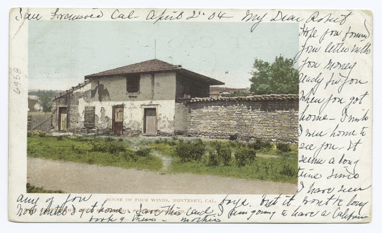
Here's an old postcard view of the front,
courtesy of the New York Public Library's Digital Collection
The house became the residence of Mexican Governor of California, Juan Bautista Alvarado. The building was only a year or so old when Alvarado led a rebellion against the distant central government in Mexico City. There was quite a bit of back-and-forth political turmoil, but Californio became a quasi-autonomous territory under Alvarado.

In 1846, Americans became more and more present in Monterey, and for a while the area was occupied by Americans. During this time, Alvarado used the building as a store.

In 1848, Mexico lost what hold they had on California in the Mexican-American War, and it became first a US Territory then a state. During the period of occupation by the Americans during the Mexican-American War, and immediately after, the house was used as a resident by Army Captain Henry "Old Brains" Halleck who served first as an aid to General Bennet Riley, the Governor-General of California Territory and then as military Secretary of State, which allowed him to be the Governor-General's representative at the California Constitution Convention, held in near-by Colton Hall in 1849; Halleck became one of the leading authors of the constitution of the new state. According to the California Military Museum, Halleck was the Convention's "brains because he had given more studious thought to the subject than any other, and General Riley had instructed him to help frame the new constitution." While records are obscure or non-existent, it is entirely possible that he could have done some of the writing of the Constitution in the House of Four Winds.

After California achieved statehood, the House of the Four Winds became the state's first Hall of Records with the establishment of the new County of Monterey, and the County Recorder, W. C. Johnson lived there.

Glass plate negative, collection of the Monterey Civic Club
In 1906, a number of prominent Monterey women joined together to form the Women's Civic Club (later renamed Monterey Civic Club) with the mission to acquire and preserve some Monterey's early adobe buildings before they succumbed to time and progress; the House of Four Winds was purchased in 1914 and was renovated, becoming the orgaization's clubhouse. Because of the age of the Archive's print and the presence of domestic animals, it is believed that our photograph was taken about the time the club acquired the building.

The restoration of the building was guided by Myron Oliver, at the time a leading expert on the history of early Monterey architecture and home decor. The facade has been restored to how it looked in the 1850s. He chose the furnishings carefully, and amongst the collection is the original desk from Colton Hall upon which the final draft of the Constitution was written.

As was noted earlier, our photograph could not be dublicated today, because in order to carry on their activites and yet not disturb their historic building, in 1953 the Monterey Civic Club built an addition onto the back of the building which now serves as a recreation and event hall, and a large Masonic Hall was built next door, as can be seen in the Google Maps view below.


More information on the house:
Special thanks to Barbara Siebeneick of the Monterey Civic Club for the reserch help!


Sunday, January 29, 2017

A Sunday at Venice Beach

Ok, truth be told, I don't know what day of the week this photo was taken, but it shows a very, very crowded Venice Beach. Now, who the heck would go to Venice just to sit under a black umbrella?


To the south of our scene is the Abbot Kinney Pier, below. This view is helpful in dating the photo. The pier went through several drastic changes over its history, the most dramatic after it suffered a catastrophic fire in December, 1920. Based on the Ferris Wheel, the auditorium, the three masts of the Ship Cafe just shoreward of the Ferris Wheel and the location of the roller coaster (on the north side of the pier), this scene appears to have been taken some time before the fire, which would put the date sometime between July 1905 and December 1920. When it was rebuilt afterwards, the roller coaster was located on the south, rather than the north side.


I've tried to find out information on Morley's, presumably a restaurant, but have come up empty...please comment at the bottom of the post if you have any info on this establishment.


Lots of straw hats
Some comparative images (mostly old post cards) can be found at VirtualVenice. Another history website. And details on the pier's construction.

Sunday, October 30, 2016

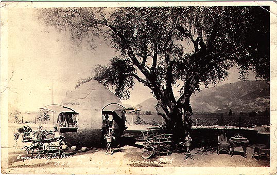
Pasadena's Orange Inn

Back in the 1920s and 1930s, there were four things true of Central and Southern California: Towns were far apart, the weather was hot, cars had no air conditioning, and orange groves proliferated everywhere. As a result, numerous juice stands shaped like giant ornages sprung up everywhere along the north-south Central California Highway 99 and of course the famous east-west Route 66. Parched travellers (and presumably their children) could stop on a hot day and slack their thirst.

Determining the location of the particular stand shown in our photo proved to be a bit of a challenge, until I came across the Giant Oranges page on the RoadsideArchitecture.com website. There I found a scan of a real-photo postcard (click here to see it) showing the same Orange Inn vintage orange juice stand under an old oak tree. The good news is that after I enhanced the postcard image a bit, the writing at the bottom became distinguishable, and reads:"Everything in Orange. Foothill Blvd, Pasadena, Calif." Foothill Blvd was part of Route 66.

In discussing this with Debra, the owner of RoadsideArchitecture.com, she put me on to another site displaying the same postcard, the Homestead Museum in the City of Industry. And they even listed the Orange Inn's former address: 2458 Foothill Blvd.

Now comes the sad part: I looked the address up on Google Maps' Streetview feature and compared the ridgeline in the backgrounds of the above photo and the post card, and got this approximate view of the site:


Well, at least you can probably still get orange juice at that Mobil station....

While the Orange Inn is long gone, a few other orange stands still stand today! Including one in Florida!

Thursday, October 6, 2016

A Stop in Bishop

For the first #ThrowbackThursday, or #TBT in each month, we feature a photo showing America's love for its new cars and trucks.

For those not familiar with eastern California, you might not have heard of the little town of Bishop. It is a unique place, sitting at the northern end of the Owens Valley, the gateway to the eastern Sierras. Bishop has a history steeped in mining and mountaineering. John Muir used to come though upon occasion. It is a watering hole on the way to Mammoth Mountain, Mono Lake and points north. For hunters and fisherfolk, hikers and climbers, it is a place to eat and fuel before heading into the back country.


So what's this gentleman doing? His truck appears to be loaded up...is he heading for a mining operation? A camp?