Outside of hard-core classic car enthusiasts, few people have ever heard of the Hupmobile (I hadn't before researching this photo), so this really is a little bit of Lost America Found. I was having difficulty in identifying the car when I remembered rule number one: look at the back of the print, because sometimes, just sometimes, you get lucky and the photographer might have made a note. There, in light pencil, was written "Billie C. and our Hup." A quick scan through the manufacturers list at www.american-automobiles.com and Hupmobile popped out, and sure enough, there's a Hupmobile club with a pretty comprehensive website. This appears to be a 1924 or 1925 two-door sedan. I still don't, however, know who Billie C. was.
Robert Hupp, who had worked for Ford and Olds for a bit, partnered with his brother Louis to form Hupmobile and came out with their first car, the Model 20, in 1908. The company hit its stride in the 1920s, giving Ford and Chevrolet some decent competition. Hups generated a reputation for being reliable yet unpretentious. The Great Depression hit them hard, and to try to generate consumer interest, they turned to famed designer Raymond Lowrey for a couple of designs, but to no avail, and with resources becoming scarce at the beginning of WWII, the company folded.
Monday, February 13, 2017
Sunday, February 12, 2017
Building the Pittsburg Shops
![]() |
| Original, faded condition |
When Arthur Stillwell founded the KCS in 1887, he had plotted the line's route from Kansas City to Port Arthur, Texas, he pretty much drew a straight line on the map. That line did not go through Pittsburg, although it wasn't that far away. Pittsburg already had three railroads passing through the town, but it also had an economically aggressive town leadership, headed by founding father Franklin Playter, who offered Stillwell a deal: shift the line so that it passed through the town, and the town government would help with the additional needed right-of-way. Playter then upped the ante, and asked Stillwell to appoint the town as a division point, and build its shops there, with the town helping to subsidize that as well. Stillwell agreed to this as well. When the tracks finally arrived in Pittsburg in 1893, the line was then know as the Kansas City, Pittsburg and Gulf Railroad, and for years after, the sprawling facility was known simply as the P&G Shops.
Fifty years later, the Shops had grown to cover over 100 acres, with the rail yard covering another two hundred, and were a huge economic engine for the city and region for years.
The website Pittsburg Memories has extensive maps and photo documentation of the shops, including interior views of the building in our photo once it had been completed. This map shows our building on the upper right. The view of our photo is looking at the upper left corner of the building as it's shown on the map. A corresponding aerial photo can be seen here.
Times change, however, and with the advent of interstate highways and the robust trucking industry, the freight that supported railroads became less local and more point-to-point. Eventually, KCS decided that it was just not economical to maintain two large shops operations, and so most of the repair activity from Pittsburg was relocated to the KCS shops in Shreveport LA. The buildings then sat idle for a number of years, becoming a magnet for vandals. In June, 2010, the three-month process of demolishing this once-bustling economic center began.
Labels:
Architecture,
Construction,
Occupational,
Railroad
Location:
Pittsburg, KS 66762, USA
Friday, February 10, 2017
The Teeter-Totter
For #FamilyPhotoFriday, I offer you the simple pleasures of spending some time on a crude but effective teeter-totter.
Thursday, February 9, 2017
Miss Howarth's North Side Grade 4 Class
I hate it when valuable bits of family history get separated from their families. This class photo, picked up in an antique store in a Chicago suburb, is worn and faded, but two things help: the photographer notated the class and teacher on the negative, and the sister of two of the students pictured wrote names on the back. This is presumably North Side school, grade 4, with a Miss Howarth as the teacher. The photograph itself is typical of the 1890s.
On the back has been written "George Hasel, Margaret (Meg) Hasel, bro & sister of Ann (Hasel) Gourley".
![]() |
| Contrast enhanced and tone mapped in order to bring out faded details. Presumably that's the principal or headmaster at the far right. |
So here are the results of my short bit of research (for the benefit of anyone doing genealogy research on these names) who these folks were: Findagrave.com has an entry for an Anna Hasel Gourley, born June 25, 1891 in Fairbury, Livingston Co. Illinois. The site also has an entry for Margaret G. Hasel, born 1888 (and listed on the site as Anna's sister); while nothing is said of the location of her birth, her grave is in Fairbury, Livingston Co. Ill. Since most fourth graders are nine or ten years old, that would put this photo at 1897 or 1898, consistent with the physical characteristics of the print.
Information on George Hasel is much more tenuous. Findagrave has several by that name, but none buried in Illinois, and only one, George Frank Hasel, who was born in the right date range (June 3, 1887); he is buried in California, so he might be the brother...or his birth date might be just a coincidence.
Geni.com has an entry for Simon J Hasel who lived (and died) in Fairbury and had eight children, three of which are Anna B. Gourley, Margaret G. and George Frank, which to me confirms that this is the correct family matching the photo. If anyone is doing research on this family and has thoughts on these kids, please leave a comment below!
As for Miss Howarth, Findagrave has an entry for a Alice Hindle Howarth, also buried in Fairbury, Illinois. She was born April 6, 1849, so if this photo was taken in 1898, that would make her 49 years old, consistent with her appearance in the photo. As for her being referenced as "Miss" when Howarth is her married name, that is still today a common practice for teachers (my wife is one).
Fairbury is a small town in north-central Illinois, about 80 miles as the crow flies from Elk Grove Village, where the antique store is that had this photo. The population of Fairbury in 2000 was 3,968 and in 1900 was 2,187.
Information on George Hasel is much more tenuous. Findagrave has several by that name, but none buried in Illinois, and only one, George Frank Hasel, who was born in the right date range (June 3, 1887); he is buried in California, so he might be the brother...or his birth date might be just a coincidence.
Geni.com has an entry for Simon J Hasel who lived (and died) in Fairbury and had eight children, three of which are Anna B. Gourley, Margaret G. and George Frank, which to me confirms that this is the correct family matching the photo. If anyone is doing research on this family and has thoughts on these kids, please leave a comment below!
As for Miss Howarth, Findagrave has an entry for a Alice Hindle Howarth, also buried in Fairbury, Illinois. She was born April 6, 1849, so if this photo was taken in 1898, that would make her 49 years old, consistent with her appearance in the photo. As for her being referenced as "Miss" when Howarth is her married name, that is still today a common practice for teachers (my wife is one).
Fairbury is a small town in north-central Illinois, about 80 miles as the crow flies from Elk Grove Village, where the antique store is that had this photo. The population of Fairbury in 2000 was 3,968 and in 1900 was 2,187.
![]() |
| The two Hasel children are marked with blue pen X's. |
Monday, February 6, 2017
Double Date to a T
There's nothing like a drive in the country in a way that couldn't be done just a few years before: in the convenience of a convertable Model T Touring Car! The car appears to be somewhere between a 1920 and 1922 year model.
Sunday, February 5, 2017
In the Back Yard of the House of Four Winds
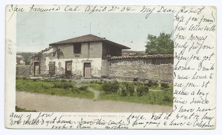
It's always fun to come across an obscure piece of history in a photo and find out that a century later the place still exists and is in fact thriving. Such is the case with the House of Four Winds.
Our photo is a real-photo postcard, probably one of several depicting the old adobe which were sold as sourvenirs. If you Google the place, you'll find a lot of images of the front of the house, the street view, both old and new, because remarkably this early adobe has been saved and restored. It is located at 540 Calle Principal in old Monterey. However, a modern photograph from this perspective, would not be possible today (more on that in a minute).
At the time the house was built, in about 1835, Alta California was a territory of Mexico (which had just won its independence from Spain fourteen years earlier) and Monterey was the capitol of the territory. Thomas O. Larkin, the only American consul to serve in Alta California, developed a large piece of land and built several houses on it, including this one just a short distance from his own (as a non-citizen, he was not permitted to actually own land, but was able to obtain several land grants in the names of his children). The house originally had a weather vane mounted to the peak of its roof, supposedly the first such device in the territory, and so the local natives called the building "The House of Four Winds" (sometimes shortened to the Spanish name La Casa de los Vientos).
The house became the residence of Mexican Governor of California, Juan Bautista Alvarado. The building was only a year or so old when Alvarado led a rebellion against the distant central government in Mexico City. There was quite a bit of back-and-forth political turmoil, but Californio became a quasi-autonomous territory under Alvarado.
In 1846, Americans became more and more present in Monterey, and for a while the area was occupied by Americans. During this time, Alvarado used the building as a store.
In 1848, Mexico lost what hold they had on California in the Mexican-American War, and it became first a US Territory then a state. During the period of occupation by the Americans during the Mexican-American War, and immediately after, the house was used as a resident by Army Captain Henry "Old Brains" Halleck who served first as an aid to General Bennet Riley, the Governor-General of California Territory and then as military Secretary of State, which allowed him to be the Governor-General's representative at the California Constitution Convention, held in near-by Colton Hall in 1849; Halleck became one of the leading authors of the constitution of the new state. According to the California Military Museum, Halleck was the Convention's "brains because he had given more studious thought to the subject than any other, and General Riley had instructed him to help frame the new constitution." While records are obscure or non-existent, it is entirely possible that he could have done some of the writing of the Constitution in the House of Four Winds.
After California achieved statehood, the House of the Four Winds became the state's first Hall of Records with the establishment of the new County of Monterey, and the County Recorder, W. C. Johnson lived there.
In 1906, a number of prominent Monterey women joined together to form the Women's Civic Club (later renamed Monterey Civic Club) with the mission to acquire and preserve some Monterey's early adobe buildings before they succumbed to time and progress; the House of Four Winds was purchased in 1914 and was renovated, becoming the orgaization's clubhouse. Because of the age of the Archive's print and the presence of domestic animals, it is believed that our photograph was taken about the time the club acquired the building.
The restoration of the building was guided by Myron Oliver, at the time a leading expert on the history of early Monterey architecture and home decor. The facade has been restored to how it looked in the 1850s. He chose the furnishings carefully, and amongst the collection is the original desk from Colton Hall upon which the final draft of the Constitution was written.
As was noted earlier, our photograph could not be dublicated today, because in order to carry on their activites and yet not disturb their historic building, in 1953 the Monterey Civic Club built an addition onto the back of the building which now serves as a recreation and event hall, and a large Masonic Hall was built next door, as can be seen in the Google Maps view below.
More information on the house:
Our photo is a real-photo postcard, probably one of several depicting the old adobe which were sold as sourvenirs. If you Google the place, you'll find a lot of images of the front of the house, the street view, both old and new, because remarkably this early adobe has been saved and restored. It is located at 540 Calle Principal in old Monterey. However, a modern photograph from this perspective, would not be possible today (more on that in a minute).
![]() |
House of the Four Winds along with the Colton Hall on the
left and the Larkin House (which also survives) on the right.
Collection of the Monterey Civic Club
|
| Here's an old postcard view of the front, courtesy of the New York Public Library's Digital Collection |
In 1846, Americans became more and more present in Monterey, and for a while the area was occupied by Americans. During this time, Alvarado used the building as a store.
In 1848, Mexico lost what hold they had on California in the Mexican-American War, and it became first a US Territory then a state. During the period of occupation by the Americans during the Mexican-American War, and immediately after, the house was used as a resident by Army Captain Henry "Old Brains" Halleck who served first as an aid to General Bennet Riley, the Governor-General of California Territory and then as military Secretary of State, which allowed him to be the Governor-General's representative at the California Constitution Convention, held in near-by Colton Hall in 1849; Halleck became one of the leading authors of the constitution of the new state. According to the California Military Museum, Halleck was the Convention's "brains because he had given more studious thought to the subject than any other, and General Riley had instructed him to help frame the new constitution." While records are obscure or non-existent, it is entirely possible that he could have done some of the writing of the Constitution in the House of Four Winds.
After California achieved statehood, the House of the Four Winds became the state's first Hall of Records with the establishment of the new County of Monterey, and the County Recorder, W. C. Johnson lived there.
![]() |
| Glass plate negative, collection of the Monterey Civic Club |
The restoration of the building was guided by Myron Oliver, at the time a leading expert on the history of early Monterey architecture and home decor. The facade has been restored to how it looked in the 1850s. He chose the furnishings carefully, and amongst the collection is the original desk from Colton Hall upon which the final draft of the Constitution was written.
As was noted earlier, our photograph could not be dublicated today, because in order to carry on their activites and yet not disturb their historic building, in 1953 the Monterey Civic Club built an addition onto the back of the building which now serves as a recreation and event hall, and a large Masonic Hall was built next door, as can be seen in the Google Maps view below.
More information on the house:
- Calisphere has a series of early photo of the building, including a different cropping of our photo.
- Historic Monterey
- Old Monterey Foundation
- A History from the Centennial Celebration site
Thursday, February 2, 2017
Gothenburg Businessman and his Rig
This photo comes from a larger collection all centered on the Nebraska town of Gothenburg, taken in the 1915 to 1919 timeframe (much more from this collection to come). This guy appears to be a gentlman of means, so it is a bit surprising to me that he's riding around in such a rig, instead of one of the new horseless carriages!
Subscribe to:
Posts (Atom)